Azores: Best Photography Spots by Island
I thought Ireland and the Isle of Skye were green until I visited the Azores, an incredibly beautiful archipelago in the Atlantic Ocean, around 850 miles west of Portugal's mainland.
Here are some favourite photos, or 'most Instagrammable,' as people say these days, views on each of the seven (of nine) islands I visited. I was going to choose one photo per island, but couldn't resist picking two for some. The whole place is a photographer's dream. So be prepared for lots of panoramic views of caldeiras and more...
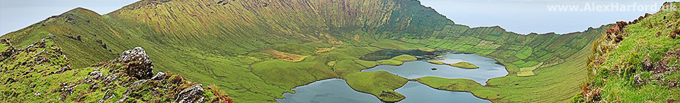
Corvo Island
Corvo's Caldeirão from near the northern rim's high point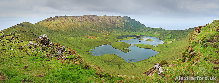
The first sight of Corvo's Caldeirão - the crater left by the volcano that formed the island - took my breath away. As I climbed to the highest point on the northern rim, the view became even more beautiful and spectacular.
Occasional (possibly muddy) trails appear to the summit, an easy walk for experienced hikers.
Flores Island
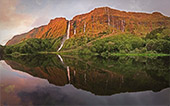
Sunset and waterfalls at Poço da Ribeira do Ferreiro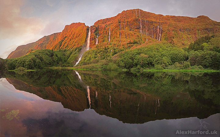
With epic waterfall-strewn cliffs both inland and on the coast, probably the most wonderful campsite I've stayed at, beautiful lakes, and other ridiculous fantasy-esque landscapes, Flores almost has more photographic spot contenders than the rest of the Azores put together.
My favourite wildlife encounter in the Azores happened at Poço da Ribeira do Ferreiro, so that gives it an edge, and it is the most famous spot on Flores. Even so, I had the place to myself for the two hours around sunset. I sat admiring the waterfalls when two herons gracefully flew in front of the falls, looking like white pterodactyls in a scene from Jurassic Park.
The above photo was taken on my third visit - the first which happened by accident. I returned for a third visit after torrential rain, which fuelled the main waterfall on the left - previously it didn't reach the ground before blowing away to a mist.
The lake is a 10-15 minute walk from a car park, slower when the path's rocks are wet - they can be very slippy.
Confusingly, the lake is also known as Poço da Alagoinha and Lagoa das Patas.
The view from near Miradouro Rocha dos Bordões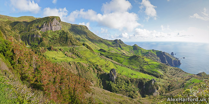
My second pick on Flores (at least until I look through more photos) is from near the Rocha dos Bordões (the rock outcrop pictured top left) viewpoint, looking towards Lajedo in the background. Flores has lots of this green and pointy scenery. Other favourite locations for it are the village of Fazenda and the pointy sea rocks at Alagoa, which resulted in the most surprising photo spot when the keyhole in the campsite's toilets acted as a camera obscura, projecting the rocks onto the wall.
Camera obscura toilet rocks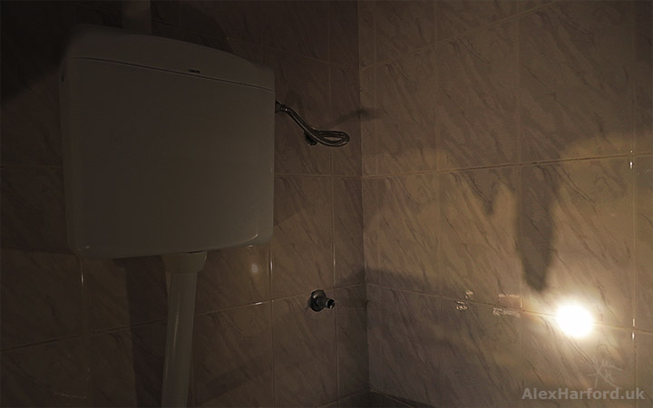
Terceira Island
Main entrance to Fortress of São João Baptista (AKA Fort of São Filipe or Fort of Monte Brasil)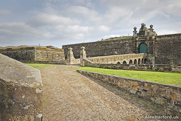
The Azores isn't all about the natural scenery. Like other towns on the islands, Angra do Heroísmo's UNESCO listed city is a picturesque place to wander, but my favourite view was of the Fortress of São João Baptista, which stands over Angra do Heroísmo with a portico of volcanic rock. From the fort, there are great views over the town and coast.
I didn't plan to visit Terceira but got stuck here after a flight cancellation from a connection. Angra do Heroísmo is one the most attractive towns in the Azores, so it was a worthy stop.
Pico Island
The very green eastern mountains of Pico, with Lagoa do Peixinho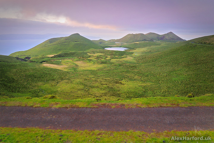
The view of Pico's crater from Piquinho (the highest point in Portugal) was spectacular, but my favourite view on the island was towards Lagoa de Peixinho - an area I visited because it looked interesting on my map. I was just in time for sunset, but when I returned earlier the following evening, the view was obscured by clouds (a common occurrence at the Azores' higher altitudes).
The drive from the EN2 to the eastern lakes is beautiful, with photogenic spots everywhere.
Faial Island
Faial's Caldeira from the circular trail's south west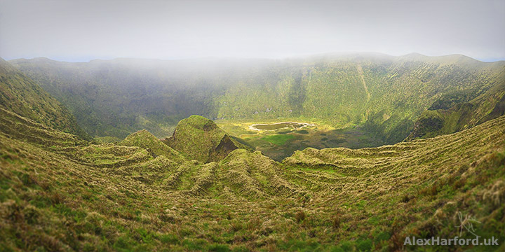
Faial's best photo spot goes to the caldeira. One morning after climbing up, I fruitlessly waited for the mist to clear, so descended and walked back via an interesting levada walk through forest in the afternoon (the levada's are 1960s water channels used for guiding water to a hydro electric plant). Uphill on a wide forest track, I was downhearted as I walked back into the cloud.
I sat on the caldeira's rim, wondering how long to wait. Frogs and birds croaked and chirped below, but nothing was visible. A Belgian guy appeared and as we chatted, we got a very slight, but spectacular, glimpse of the caldeira.
It cleared enough for me to decide to hike around the caldeira, and I was rewarded with more amazing views. Although it looks more spectacular in some of my other photos, my favourite spot was from the south west, as seen in the above photo. I like the lines of the terrain leading into the caldeira's base. The photo doesn't do justice to the size of the caldeira.
The path around the caldeira is tricky in places, but the view from the main Miradouro (viewpoint) near the road is spectacular, and it's easy to walk a chunk of the rim from either side of the viewpoint.
Pico Island from the south side of Faial's caldeira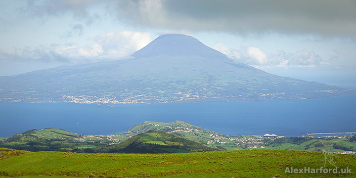
Faial probably has the best view to another of the Azores' islands with its view to Pico and its huge stratovolcano. Mount Pico's distinctive summit is covered by cloud in the above photo. To the bottom-right is Horta, Faial's main city.
Part of the crazy coastline at Capelinhos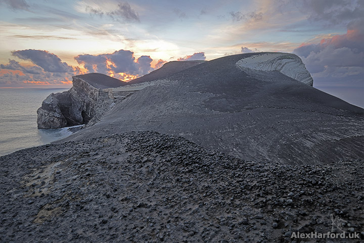
Capelinhos was spectacular, and the most non-Earth like view of my Azorean trip. Its landscape was created by a volcanic eruption that lasted for 13 months from September 1957. The once-abandoned lighthouse on the coast now houses a museum beneath it, which includes footage of the eruption.
Sao Jorge Island
The trail towards Pico da Esperança from the west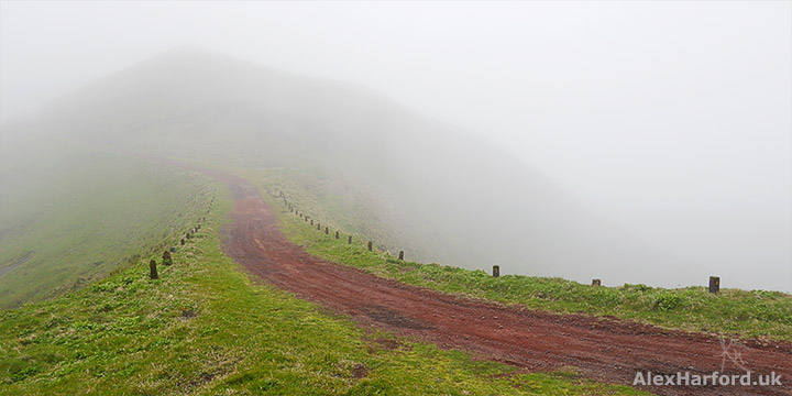 One of the lakes seen from the slopes of Pico da Esperança, with Morro Pelado in the background
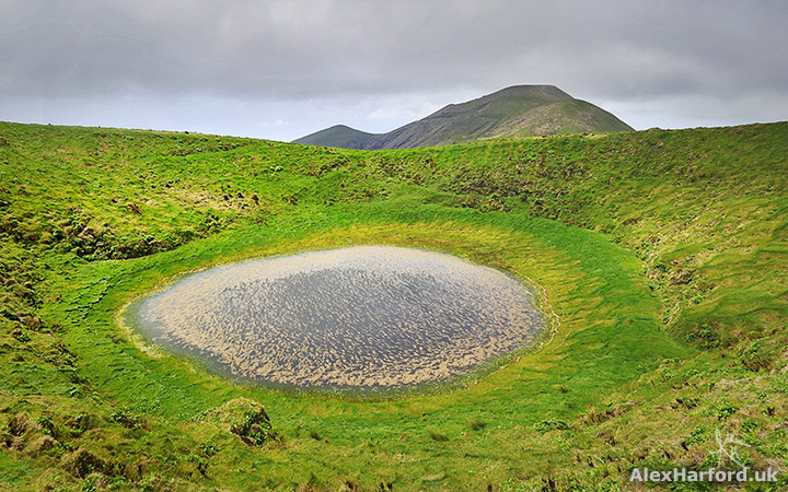
I had under 24 hours in Sao Jorge after my flight there was cancelled, which was later shortened by a broken-down rental car.
On arrival, I headed up to Pico da Esperança, Sao Jorge's highest point, despite the low cloud, rain, wind and increasingly bad weather forecast. I thought I was mad, but it turned out to be beautiful in the mist, and when it cleared I was rewarded with more amazing views. It's one of my favourite short hikes anywhere.
The weather was a reminder to be prepared in the Azores: one minute I was hot and shedding layers, the next putting them back on.
This is quite a straightforward trail, as seen in the first photo, but it becomes much narrower and steeper when climbing Pico da Esperança's summit. There are also forks on the summit trails - it'd be easy to take a wrong turn in cloud. I took the there-and-back route from the ER3, but would love to visit Sao Jorge again to complete the circular route that takes in a couple more mountains.
Other great photo spots on Sao Jorge include Fajã da Caldeira.
Sao Miguel Island
Sunset at the Boca do Inferno viewpoint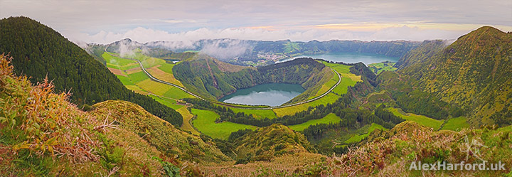
I nearly didn't see this view. On a clear morning, I was at a crowded and noisy viewpoint a five-minute walk away, so walked in the opposite direction towards a mountain where I couldn't see any people. When I returned to Miradouro da Boca do Inferno later that day, it was completely clouded over.
Two weeks later, I arrived back on Sao Miguel after visiting six other islands, on a delayed flight. The weather forecast for my final two days on Sao Miguel didn't look promising, but there seemed to be occasional clear spells. I hadn't eaten dinner, and it'd be a rush to get to Boca do Inferno. I decided to 'rush', and arrived as the sun was setting - and the breathtaking view was well worth it. The next two days were completely clouded over, meaning it wasn't worth ascending the highest peak on the island, and I wouldn't have seen the view from Miradouro da Boca do Inferno if I'd waited.
Our Lady of Peace Chapel (Nossa Senhora da Paz in Portugese)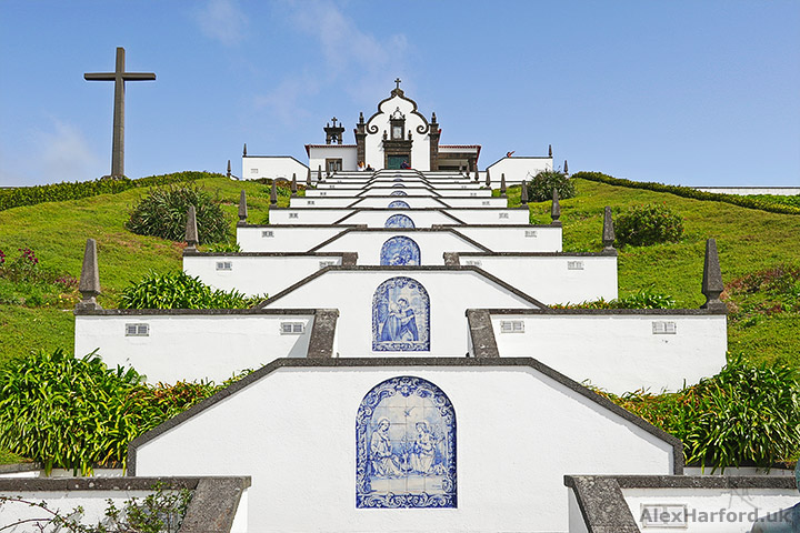
Other photogenic spots on Sao Miguel include the Hot Waterfall of Ribeira, the view down to the lighthouse at Nordeste (including a beautifully-sited waterfall if you fancy the climb back up), and the Our Lady of Peace Chapel (pictured above), especially when the blue sky matches the blue tiled scenes.
The chapel is at the top of a very steep (and at times narrow) road from Vila Franca do Campo. The views from the top are excellent, including to an islet just off the coast.
Santa Maria and Graciosa
I didn't have time to visit Santa Maria or Graciosa. If I had, I'd be heading for the Azores' highest waterfall on Santa Maria, Cascata do Aveiro, and the Martian-esque landscape of Barreiro da Faneca. On Graciosa, I'd visit Ponta da Barca, and the picturesque windmills. But who knows what other places I'd discover; the Azores are a place that reward exploration.
If you're planning to hike in the Azores, the most detailed map I found is by Freytag & Berndt (Amazon link).
Whether you've visited or not, do you have a favourite view on the Azores?
You may like
Photos of Sgùrr Alasdair and Eas Mòr (Circular Walk from Glen Brittle) Scrambling up the highest island mountain in the UK and marvelling at one of the most picturesque waterfalls I've seen (Isle of Skye)
Sgurr na Stri Circular Photo Hike from Camasunary (Skye) A wonderful walk on the Isle of Skye with amazing mountain views, red deer and The Bad Step
29 Photos of Amazing Places in The Outer Hebrides (My Highlights) I was blown away by the Outer Hebrides - incredible beaches, mountains, historical buildings and galleries
Isle of Arran, Scotland Despite its small size, at 19 miles long and 10 miles wide, Arran has a diverse landscape and is often known as 'Scotland in Miniature'
Or, see more photos and articles from Portugal
Win a print from this page! All UK residents on my mailing list eligible.


Comments